On the 2nd January, I flew out to Tanzania in Africa with my dad to climb the largest free standing mountain in the world, Mount Kilimanjaro (5,895m). To put this into perspective, Snowdon - the height mountain in Wales is 1,085m), so this was a huge challenge!
Our flight left from Humberside airport with a transfer in Schipol before arriving at Kilimanjaro airport. Tanzania are 3 hours ahead making the flight seem even longer!
Day 1
We left England at 6:10am and arrived in Tanzania at 8:40pm. Collecting our visa took a long time and it was around 30 degrees celcius... we were extremely sweaty having travelled wearing as much as possible after hearing that 1 in 7 peoples luggage does not arrive in time! The drive was 1 hour from the airport to our hotel in Arusha. We stayed in Arusha due to its higher altitude compared to the other cities closer to Mount Kili. This drive was interesting...the country have spent a lot of money on police monitoring car speed meaning police are everywhere, however no other road rules are regulated at all. Cars join the road whenever they want, cars have no headlights, there are lots of horns going, nobody stays in their lanes and there are often three cars in line across two lanes. I noticed lots and lots of people stood in large groups at the side of the long, wide, empty roads. I later found out that these groups of men were operating taxi services on their motorbikes - many of which had no headlights! The only true buildings we saw on this journey were universities... the other houses were more like tin huts. We approached two huge black gates guarded by men with guns. This was the entrance to our hotel. We were very happy to be able to have a shower.

Day 2 (2671m)
We woke up at 6am for a breakfast which consisted of an omelette and cereals. We met our team at 7 am before beginning a 5 hour drive to the start of the Rongai route. The sky was extremely clear and we could see the peak of Mount Meru - Mount Kilimanjaro's sister. Driving through the nature reserve on the way there, there were lots of people farming. Small children walking solo carrying huge baskets or branches, often on top of their heads. We learnt that the whole family works together daily to ensure food is placed on the table. We eventually arrived at the start point. The guides (we had 13 between 2 of us) had to arrange the luggage so that each man was carrying 20kg. The luggage included clothing, tents, food, drink, bowls, cutlery, sauces and first aid for 15 people! No plastic bottles are allowed on the mountain to reduce the amount of litter. After 1.5 hours of relatively easy walking, we arrived at Simba camp (2671m). Walking through the rainforest, we spotted black and white columbus monkeys swinging in the branches above us... they then joined us in the campsite in the evening. We were told that there are over 450 species of bird on the mountain but many of the large wild animals such as elephants have moved into Kenya due to the vast amount of poaching that occurs.
We had our own chef (Robert) and waiter (Duhlar). Our first meal started with a soup dish followed by fish, vegetables and potatoes. We were fed extremely well throughout the trip- it was amazing what they could cook in the mountains with very limited resources. Apart from hearing people around you going to toilet into a plastic bucket very close by and my dad cutting his head sleeping on the zip of his sleeping bag, we both slept very well on our first night in our tents.

Day 3 (3700m)
We woke up at 6am, greeted by a knock on our tent followed by a mug of coffee each. Today we changed terrain, from a rainforest to moorland area into second cave camp over an 8km hike. We spotted lots of buffalo footprints along the track and there was a clear view of the Kilimanjaro summit. We stopped for lunch were we had cucumber soup, fish and chips, green beans and carrots. It chucked it down with rain. We then hiked another 8km to our final camp of the day. The hiking was long and we moved very slowly across the mountain. My dad slept while I went to explore the camp. A river ran straight through the centre surrounded by unique trees and lots of mice and birds lived here. The surface was volcanic ash.
Despite the bad weather, my dads head had got sunburnt highlighting the contrasting weather conditions. He was very uncomfortable and our clothes were wet. As the sun set and the moon came out, the stars lit up the Kenyan towns 3700m below us. It was spectacular. For tea, we had soup, chicken leg, rice and vegetable curry. The rain was extremely heavy and noisy throughout the night, we barely slept. The guides dug mini trenches around the base of your tent to allow the water to drain into.
Checking into every campsite we were the youngest and oldest people each time! Choosing your amount of layers each day was difficult because the temperature varied so so much and whatever you did not wear, you had to carry! There were now no toilets at all... we simply went to the toilet using a hole in a shed. No luxuries. No showering. No sleep. Lots of sweating.

Day 4 (4300m)
Heading to the food tent for breakfast, two huge ravens swooped past us. The weather was much better and brighter. Breakfast: rice porridge, pink potatoe (they called it sava), vegetable omelette, orange. We trecked through an alpine desert and arrived at Mawenzi Tarn Hut. There was lots of rocks piled on top of eachother which we were asked to place a rock on top off and make a wish. For lunch we had celery soup then we had an omelette sandwich with onion barjis. This was the prettiest camp. The guides played chess. Once you had stopped walking, there was very little entertainment... my father read the same book 3 times! Small lakes were dotted around everywhere. We did an acclimatize walk up towards one of the three eruption points on the mountain. An acclimatization walk involves walking up higher (in this case, 4500m) before returning back lower to sleep (4300m). We both suffered with headaches on this walk. It felt like my brain was being squashed by my skull. The beauty of the hike we had selected was that it gave you time to acclimatize making it much more likely for you to reach the summit. For tea: pancakes and pumpkin soup followed by African stew and pineapple.
The nights were getting colder and colder as we moved higher. We were also becoming dirtier and the dried sweat on our bodies was making us cold. I slept wearing a thermal base layer, hoodie, and 3 jackets this night whilst snuggled in my sleeping bag - it was still FREEZING!
Day 5 (3800m)
As the sun rose, we made our way to the breakfast tent where our chief (Nicholas) congratulated me on having such an amazing dad! We were moving lower today, towards third cave camp which meant our headaches and sickness should go away. We were both quite excited as we knew we were summitting the following evening, however both felt very tired - sleeping in tents in gail winds at -20 degrees doesn't provide the best nights sleep! My dad was resting throughout the day whenever he got the opportunity to, although very rarely actually falling asleep. Kibou peak was behind us now providing a very pretty backdrop. The guides were walking towards the nearest stream in order to collect water for us. One of the porters suffered from altitude sickness which was a good reminder to us that we were doing well!
Day 6 (4800m)
We moved from third cave to school hut camp (4800m) which took 3 hours. School hut was a private camp ensuring we were the only people at it. It was a very cloudy morning but there was no wind at all. The hike was much steeper today and we were repeatedly told to walk 'pole pole' (slowly, slowly) to prevent altitude sickness. The rocks were much larger now and the ground was sandy. We passed a buffalo carcass. We reached 5000m on our acclimatization walk and my father hated travelling back down the mountain. This was our final walk before the summit.We knew the two largest factors effecting us summitting would be, the contrasting weather conditions and how we coped with altitude sickness. We went to sleep at 4:30pm with facemasks on to block out the bright sun. My father did not sleep at all in this period.
SUMMIT (5895m)
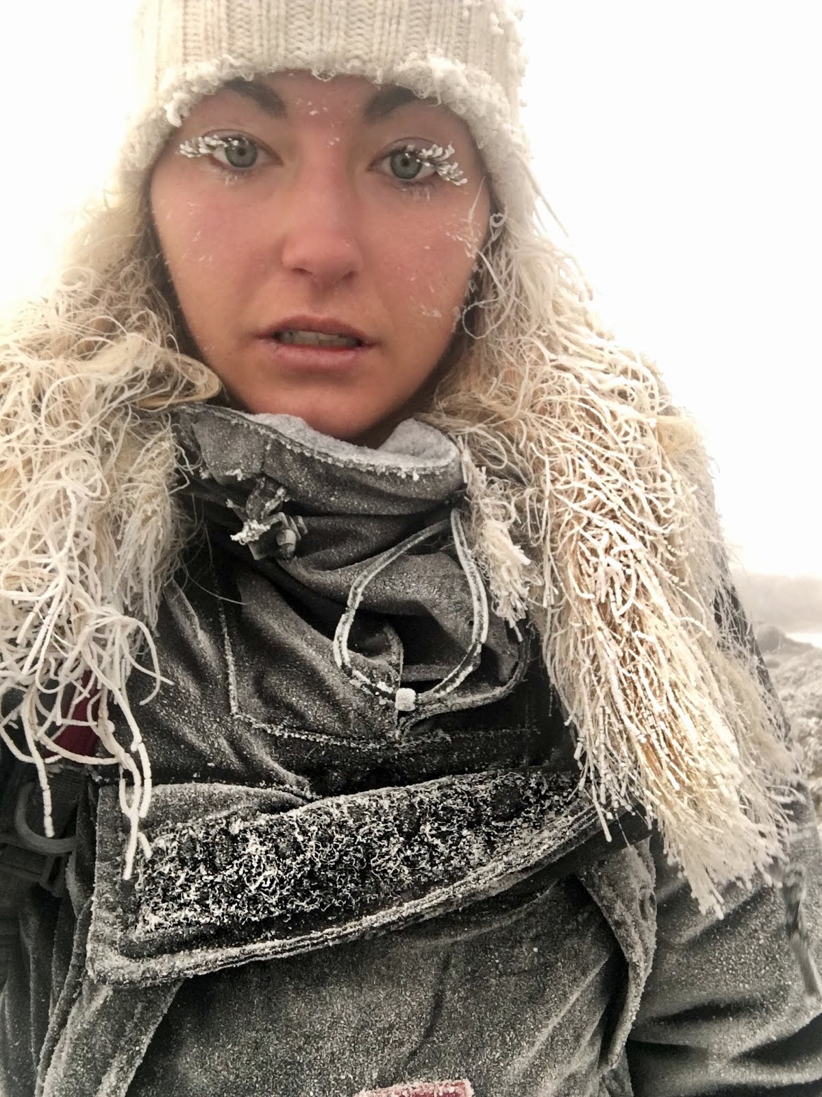
 We woke up at 11 pm for our breakfast. Neither of us were able to stomach our breakfast - I was so nervous! It was pitch black as we set off on our 7 hour hike for summit at midnight. I spotted a shooting star just before we started trecking. We had head torches on which highlighted the earth in a small circle just ahead of you. The walk was very steep and challenging. My fathers head torch died after 15 minutes - very typical of my father as he is rubbish at working electrical products. We walked with three guides for two hours alone before joining the other groups on the main pathway to the summit. We travelled in single file. Many people were falling over, lots of people were laid out resting and some people were being sick. You needed to keep a strong mind. My father was really struggling but he knew he was fit and capable enough to keep going past these people. When I spoke to him, he was replying nonsense and he looked glazed over. He kept falling up the mountain and the guides had to take his luggage from him. My father was using Gilmoors point (the first marked point on the highest rim of the volcanoe) as a point to reach for motivation. I did not think he was going to make it but he kept ploughing on. The guides tried to keep the hike as enjoyable as possible, singing loudly as we moved up the mountain. It was hard to keep focus when all you could see was a tiny circle of land lit up infront of you for 7 hours! Everything else was blackness. As we approached Gilmoors point, it was still very dark. We were one of the first people to reach the top rim. As we climbed over the ridge, a blizzard began... it was -20 and the snow was falling thick and fast. We were freezing. The snow had built up and was extremely thick (1m deep) around the path. We pushed on and reached Steller's point before getting to the summit. It was so emotional! My hair had frozen around my face and even my eye lashes had turned into small icicles. It was around -30 at the summit. We had a very quick picture before the guides rushed my father down for safety. I followed hastily. Coming down the mountain, everyone else still on their way up congratulated us! The guides practically dragged us down the mountain, taking us under the arm. It was the fasted we had moved all week by a long way
Day 7 (3700m)
We reached the summit at 6:10 am and came straight back down to Horombo huts using the Marangu route. This campsite had its own toilets and actual buildings were there. This camp site was incredibly different to the other camps that we had been to. My dad could not eat when we stopped at Kibou huts. He felt very sick. My father donated his clothes to the guides. We had dropped from 5900m to 3700m. This was very, very tough. We had been away for around 30 hours. We had reached the summit of the heighest free standing mountain in the world. We had also hiked around 19km.
Day 8
 We had the best night sleep ever (8:45pm -> 6am). Our guides performed a dance for us as they were very excited to be going home. I joined in. We hiked through large groups of cactus trees and into a thick rainforest. In the rainforest, we passed a dic dic. This hike covered 21km, a nice half marathon to finish our hiking week! We reached our pick up point at about 1 o clock and took the bus home. On the bus we had 7 tiny bananas each. The bus stunk... 13 guides plus my father and I, all who had been hiking for 7 days in temperatures ranging from 30 degrees to minus 30 degrees. The smells were repulsing!
General routine
6:30 am wake up and pack bags within the tent
7:00 am wash (bowl of warm water)
7:30 am breakfast
8-12 am walk
12 am- lunch (soup and main)
4 pm - popcorn, coffee, peanuts (snacks)
6pm - tea (soup, main dish and fruit)
Extra information
In the 1990's, people believed God lived at the top of the mountain. They thought nobody could climb to the summit because God's curse would kill them. They were mistaking this death cause with hypothermia.
In 1995, our chief guide first summitted the mountain. He stayed in natural caves the whole way up, keeping warm by a single blanket. He hated every minute of it. He swore he would never climb again. He took this back when employment elsewhere seemed impossible.
It is a rule on the mountain that you take as many guides to the summit as there are climbers.
There are still tribes who live on the mountain!


